Most fleets have a GPS tracking and telematics platform like Fleetistics or Geotab which enables viewing the location of a vehicle on a map. This simple process can have a tremendous impact on the allocation of assets. If a fleet is not using GPS trackers the PubSafe mobile app can be used in a similar fashion for short periods, without GPS installation, and to visibility across organizations for a limited duration. Fleet tracking enables emergency operations centers and managers to improve decision making.
Some of the benefits of integrating telematics with PubSafe include:
Staging assets near the disaster area
Moving the right types of assets to certain types of area. Ex. Moving boat teams to coastal areas.
Ensure first responders and assets are not in harms way prior to the disaster
As help requests are made through the PubSafe mobile app, assets can be shifted based on real-time citizen input
Assets from multiple agencies or departments can be integrated to reduce information silos
The politics
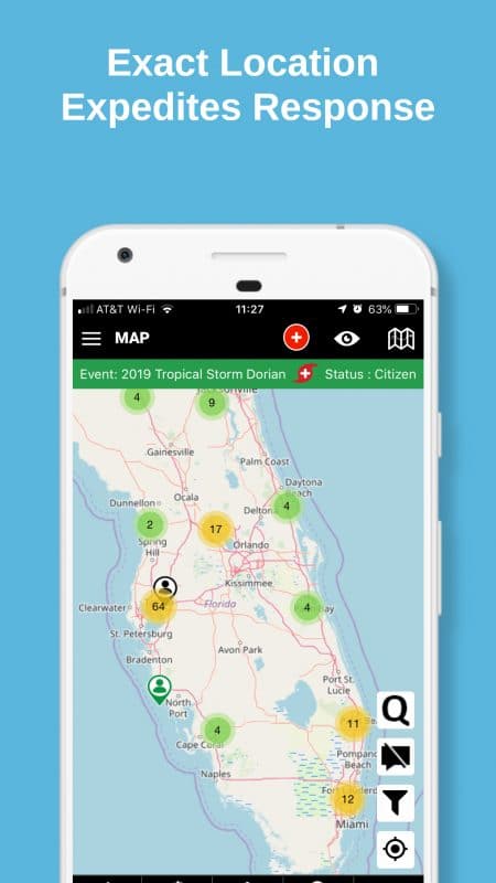
All citizens are entitled to equal access to emergency management services. By utilizing the PubSafe app and GPS tracking, emergency managers can monitor which areas are receiving emergency services and which may need more resources. Some areas are known to be low income and low lying will need a disproportional amount of resources due to the inability of citizens to help themselves in water rescues. Other areas previously unknown to emergency management may become visible as help requests are made from specific areas. Knowing the location of assets, skills, and asset types enable improved real-time decision making and equitable asset distribution. Post-disaster the data can be studied to understand if equitable goals were achieved and how improvement can be made in the future.
Consolidated Vehicle Tracking
The primary challenge with asset tracking in a disaster is the joint agency integration of information, information silos. In a major hurricane response, rescue teams are coming from across the country in phases to bring continuous relief over a prolonged period of time. Without unified communications and fleet tracking data, the local EOC and FEMA will have a very difficult time efficiently deploying these resources. Typically teams will appear in the area, have to check-in, spend hours sitting around until the right person learns of their presence, and then get deployed hours or days later.
The PubSafe mobile app offers a solution to sharing location information across information silos. One mobile app can be implemented for a week or month for one specific disaster. Now all users are visible at one time, on one platform. With the growing capabilities of PubSafe, EOCs, and even FEMA thousands of miles away will be able to see how assets are positioned in relation to the help requests being received. FEMA can provide response support and prepare logistics utilizing real-time data direct from those in need of rescue.
Case Study: Hurricane Maria
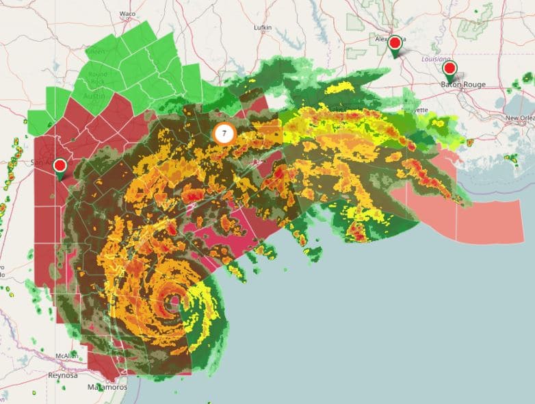
When Hurricane Maria slammed into Puerto Rico people were in dire straights for assistance. A lot of resources were needed in many areas across the island. Some areas were completely cut off physically and with communication. FEMA jumped into action and moved tons of supplies to the port in San Juan where an immediate log jam was created. Things went downhill from there.
With the widespread use of the PubSafe mobile app and integrated telematics on government vehicles, emergency managers and FEMA can see what people need and their exact location in relation to vehicles, convoys, and supplies. Instead of sending supplies to San Juan, it would have been easy to see the help requests coming from many areas. With roads closed in some directions, shipping supplies to other ports would have enabled logistics to be transported to these areas. Real-time information would have revealed a broader need which would have led to distribution through smaller, but more in quantity, demarcation points around the island.
FEMA would have been able to see areas that needed water, instead of boat rescues. Real-time data provides visibility on “hot spots” and how hot spots shift by changes in help requests and emergencies. By monitoring SitReps, the EOC and dispatchers can better deploy rescue and logistics teams. On the PubSafe platform, central user tracking is achieved for safety and efficiency.
OpenSource EV Charging Station Project During a disaster EV owners have to plan ahead due to limited charging station opportunities and the time it takes to recharge an electric vehicle. Rapid rechargers take 30 minutes and there may only be 1-2 charging...
The PubSafe mobile app team (formerly the Aftermath Data mobile app) deployed to Nebraska to assist where needed utilizing the SherpATV. Using the app in a real flood highlighted some of the features needed for the app to be more effective. It did reiterate the need...


Recent Comments